


Châteaudouble - Bois des Prannes - Ampus

Sugg
User
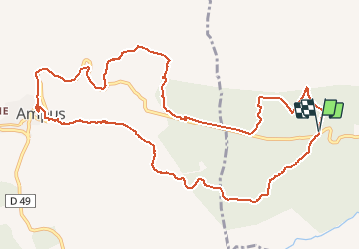

Length
13.8 km

Max alt
663 m

Uphill gradient
280 m
Km-Effort
17.5 km

Min alt
513 m

Downhill gradient
278 m
Boucle
Yes
Creation date :
2020-01-14 10:38:48.09
Updated on :
2020-01-14 10:41:50.666
3h45
Difficulty : Medium

FREE GPS app for hiking
 SityTrail
IGN / Geographical institutes
SityTrail Plus
The world is yours!
About
Trail Walking of 13.8 km to be discovered at Provence-Alpes-Côte d'Azur, Var, Châteaudouble. This trail is proposed by Sugg.
Description
Nouveau parcours pour le 15 janvier 2020
A adapter sur le terrain en fonction de la réalité !
Positioning
Country:
France
Region :
Provence-Alpes-Côte d'Azur
Department/Province :
Var
Municipality :
Châteaudouble
Location:
Unknown
Start:(Dec)
Start:(UTM)
292730 ; 4831112 (32T) N.
Comments