


Vercors Croix Perrin

c.gourme
User

Length
11.1 km

Max alt
1667 m

Uphill gradient
607 m
Km-Effort
18.8 km

Min alt
1123 m

Downhill gradient
496 m
Boucle
No
Creation date :
2020-01-14 09:18:56.0
Updated on :
2020-01-14 14:42:39.066
3h58
Difficulty : Medium

FREE GPS app for hiking
 SityTrail
IGN / Geographical institutes
SityTrail Plus
The world is yours!
About
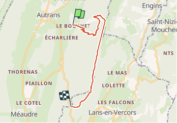
Trail Walking of 11.1 km to be discovered at Auvergne-Rhône-Alpes, Isère, Autrans-Méaudre en Vercors. This trail is proposed by c.gourme.
Positioning
Country:
France
Region :
Auvergne-Rhône-Alpes
Department/Province :
Isère
Municipality :
Autrans-Méaudre en Vercors
Location:
Autrans
Start:(Dec)
Start:(UTM)
701276 ; 5005111 (31T) N.
Comments