


flassans

clintest
User
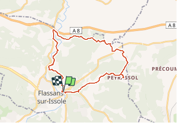

Length
17.3 km

Max alt
321 m

Uphill gradient
382 m
Km-Effort
22 km

Min alt
203 m

Downhill gradient
379 m
Boucle
Yes
Creation date :
2020-01-14 18:16:07.876
Updated on :
2020-01-14 18:16:59.114
--
Difficulty : Medium

FREE GPS app for hiking
 SityTrail
IGN / Geographical institutes
SityTrail Plus
The world is yours!
About
Trail On foot of 17.3 km to be discovered at Provence-Alpes-Côte d'Azur, Var, Flassans-sur-Issole. This trail is proposed by clintest.
Positioning
Country:
France
Region :
Provence-Alpes-Côte d'Azur
Department/Province :
Var
Municipality :
Flassans-sur-Issole
Location:
Unknown
Start:(Dec)
Start:(UTM)
274960 ; 4805678 (32T) N.
Comments