


montclar

Mascart
User
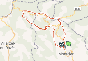

Length
9.7 km

Max alt
404 m

Uphill gradient
271 m
Km-Effort
13.3 km

Min alt
238 m

Downhill gradient
271 m
Boucle
Yes
Creation date :
2020-01-14 12:29:19.844
Updated on :
2020-01-15 13:56:18.326
2h45
Difficulty : Medium

FREE GPS app for hiking
 SityTrail
IGN / Geographical institutes
SityTrail Plus
The world is yours!
About
Trail Walking of 9.7 km to be discovered at Occitania, Aude, Montclar. This trail is proposed by Mascart.
Description
Circuit des sangliers
Positioning
Country:
France
Region :
Occitania
Department/Province :
Aude
Municipality :
Montclar
Location:
Unknown
Start:(Dec)
Start:(UTM)
438769 ; 4776368 (31T) N.
Comments