


barbieres

meillon
User
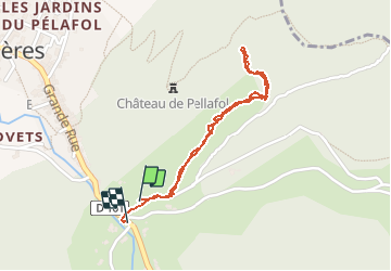

Length
1.9 km

Max alt
598 m

Uphill gradient
134 m
Km-Effort
3.7 km

Min alt
434 m

Downhill gradient
150 m
Boucle
Yes
Creation date :
2020-01-03 14:35:24.593
Updated on :
2020-01-15 18:11:59.932
1h06
Difficulty : Very easy

FREE GPS app for hiking
 SityTrail
IGN / Geographical institutes
SityTrail Plus
The world is yours!
About
Trail Walking of 1.9 km to be discovered at Auvergne-Rhône-Alpes, Drôme, Barbières. This trail is proposed by meillon.
Positioning
Country:
France
Region :
Auvergne-Rhône-Alpes
Department/Province :
Drôme
Municipality :
Barbières
Location:
Unknown
Start:(Dec)
Start:(UTM)
669272 ; 4979853 (31T) N.
Comments