Trail Other activity Schwellbrunn - Challenge_08V2 - Photo
 merlot
merlot

User

© OpenStreetMap contributors
Length
Length
61 km
Max alt
Max alt
1234 m
Uphill gradient
Uphill gradient
2098 m
Km-Effort
Km-Effort  
89 km
Min alt
Min alt
618 m
Downhill gradient
Downhill gradient
2095 m
Boucle
Boucle
Yes
Creation date :
2014-12-11 00:00:00.0
Updated on :
2014-12-11 00:00:00.0

(0 Reviews)

Other activity
Other activity
--
Difficulty : Unknown

Scan this QR Code to open this trail in the SityTrail application

FREE GPS app for hiking

Logo SityTrail SityTrail

IGN / Geographical institutes

Download SityTrail from the App Store Download SityTrail from Google Play

Logo SityTrail SityTrail Plus

The world is yours!

Download SityTrail from the App Store Download SityTrail from Google Play Download SityTrail on Huawei AppGallery

About

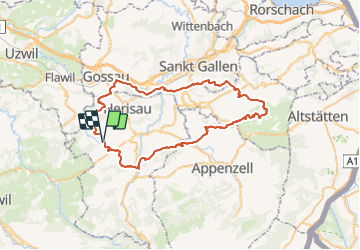
Trail Other activity of 61 km to be discovered at Appenzell Ausserrhoden, Hinterland, Schwellbrunn. This trail is proposed by merlot.

Description

Herisau,Flawiler Egg, Wolfertswil,Böschenbach,Hoffeld, Ebersol,Necker, Spreitenbach, Reitenberg, Heiterswil, Hemberg, Bächli,Schönau, Urnäsch, Gonten, Appenzell, Haslen,Stein, Hundwil, Herisau

Elevation profile

Positioning

Country:
Switzerland
Region :
Appenzell Ausserrhoden
Department/Province :
Hinterland
Municipality :
Schwellbrunn
Location:
Unknown
Start:(UTM)
518592 ; 5244550 (32T) N.


Close
My subscriptions