


Ermitage Frère Joseph - La Ronde Bruche -Haut du Riant - Haut du Rouge Gazon - Abri Forgoutte - GR533 et retour

patrickbeyrath
User
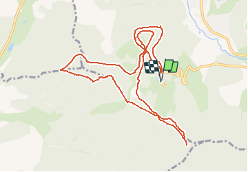

Length
11.6 km

Max alt
1107 m

Uphill gradient
362 m
Km-Effort
16.5 km

Min alt
857 m

Downhill gradient
363 m
Boucle
Yes
Creation date :
2020-01-17 06:46:44.674
Updated on :
2020-01-17 07:14:03.551
--
Difficulty : Medium

FREE GPS app for hiking
 SityTrail
IGN / Geographical institutes
SityTrail Plus
The world is yours!
About
Trail On foot of 11.6 km to be discovered at Grand Est, Vosges, Ventron. This trail is proposed by patrickbeyrath.
Positioning
Country:
France
Region :
Grand Est
Department/Province :
Vosges
Municipality :
Ventron
Location:
Unknown
Start:(Dec)
Start:(UTM)
340286 ; 5310253 (32T) N.
Comments