


Montagna le Reconduit

drarep
User
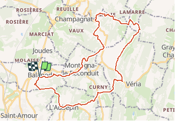

Length
22 km

Max alt
591 m

Uphill gradient
737 m
Km-Effort
32 km

Min alt
241 m

Downhill gradient
732 m
Boucle
Yes
Creation date :
2020-01-17 12:50:25.677
Updated on :
2020-01-17 12:58:49.463
6h38
Difficulty : Difficult

FREE GPS app for hiking
 SityTrail
IGN / Geographical institutes
SityTrail Plus
The world is yours!
About
Trail Walking of 22 km to be discovered at Bourgogne-Franche-Comté, Jura, Balanod. This trail is proposed by drarep.
Positioning
Country:
France
Region :
Bourgogne-Franche-Comté
Department/Province :
Jura
Municipality :
Balanod
Location:
Unknown
Start:(Dec)
Start:(UTM)
680993 ; 5147254 (31T) N.
Comments