


17.01.2020 - QUELNEUC

babeth35
User
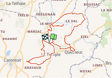

Length
25 km

Max alt
104 m

Uphill gradient
381 m
Km-Effort
31 km

Min alt
14 m

Downhill gradient
381 m
Boucle
Yes
Creation date :
2020-01-17 07:53:36.0
Updated on :
2020-01-17 15:31:03.095
6h40
Difficulty : Difficult

FREE GPS app for hiking
 SityTrail
IGN / Geographical institutes
SityTrail Plus
The world is yours!
About
Trail Trail of 25 km to be discovered at Brittany, Morbihan, Carentoir. This trail is proposed by babeth35.
Positioning
Country:
France
Region :
Brittany
Department/Province :
Morbihan
Municipality :
Carentoir
Location:
Carentoir
Start:(Dec)
Start:(UTM)
567822 ; 5297705 (30T) N.
Comments