


2020-01-19 Forêt de l'Îsle-adam

Bernardb44
User
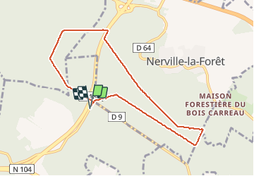

Length
7.9 km

Max alt
176 m

Uphill gradient
138 m
Km-Effort
9.7 km

Min alt
103 m

Downhill gradient
138 m
Boucle
Yes
Creation date :
2020-01-19 13:16:21.359
Updated on :
2020-01-19 15:23:47.728
1h46
Difficulty : Easy

FREE GPS app for hiking
 SityTrail
IGN / Geographical institutes
SityTrail Plus
The world is yours!
About
Trail Walking of 7.9 km to be discovered at Ile-de-France, Val-d'Oise, Villiers-Adam. This trail is proposed by Bernardb44.
Positioning
Country:
France
Region :
Ile-de-France
Department/Province :
Val-d'Oise
Municipality :
Villiers-Adam
Location:
Unknown
Start:(Dec)
Start:(UTM)
445732 ; 5436944 (31U) N.
Comments