


BELBRIETTE PARGASPARD DUVOID MILIEUSURCENEUX

surceneux
User
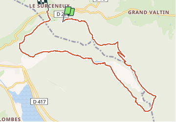

Length
10.9 km

Max alt
938 m

Uphill gradient
226 m
Km-Effort
14.1 km

Min alt
766 m

Downhill gradient
274 m
Boucle
No
Creation date :
2020-01-19 14:35:21.044
Updated on :
2020-01-19 16:45:06.23
2h02
Difficulty : Easy

FREE GPS app for hiking
 SityTrail
IGN / Geographical institutes
SityTrail Plus
The world is yours!
About
Trail Walking of 10.9 km to be discovered at Grand Est, Vosges, Ban-sur-Meurthe-Clefcy. This trail is proposed by surceneux.
Positioning
Country:
France
Region :
Grand Est
Department/Province :
Vosges
Municipality :
Ban-sur-Meurthe-Clefcy
Location:
Unknown
Start:(Dec)
Start:(UTM)
348182 ; 5328733 (32U) N.
Comments