


le Murier

Sylvie Mathiot
User
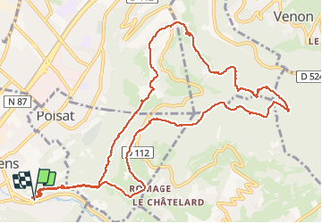

Length
14.6 km

Max alt
711 m

Uphill gradient
600 m
Km-Effort
23 km

Min alt
255 m

Downhill gradient
606 m
Boucle
Yes
Creation date :
2020-01-19 08:34:25.294
Updated on :
2020-01-20 10:37:39.998
5h16
Difficulty : Very easy

FREE GPS app for hiking
 SityTrail
IGN / Geographical institutes
SityTrail Plus
The world is yours!
About
Trail Walking of 14.6 km to be discovered at Auvergne-Rhône-Alpes, Isère, Eybens. This trail is proposed by Sylvie Mathiot.
Positioning
Country:
France
Region :
Auvergne-Rhône-Alpes
Department/Province :
Isère
Municipality :
Eybens
Location:
Unknown
Start:(Dec)
Start:(UTM)
716617 ; 5003069 (31T) N.
Comments