


z callian 21-01-20

cb8310
User
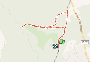

Length
4.9 km

Max alt
401 m

Uphill gradient
74 m
Km-Effort
5.9 km

Min alt
373 m

Downhill gradient
73 m
Boucle
Yes
Creation date :
2020-01-21 08:44:15.685
Updated on :
2020-01-22 08:38:13.87
--
Difficulty : Easy
1h45
Difficulty : Very easy

FREE GPS app for hiking
 SityTrail
IGN / Geographical institutes
SityTrail Plus
The world is yours!
About
Trail On foot of 4.9 km to be discovered at Provence-Alpes-Côte d'Azur, Var, Tourrettes. This trail is proposed by cb8310.
Description
encore une très belle rando à faire en été dans les sous-bois avec une partie de la boucle que nous n'avons pas pu faire à cause,une nouvelle fois d'une propriété privée
Positioning
Country:
France
Region :
Provence-Alpes-Côte d'Azur
Department/Province :
Var
Municipality :
Tourrettes
Location:
Unknown
Start:(Dec)
Start:(UTM)
317678 ; 4833629 (32T) N.
Comments