


2020-01-21_09h00m32_wq5fMMoQFkE-2

gerardmicheline
User

Length
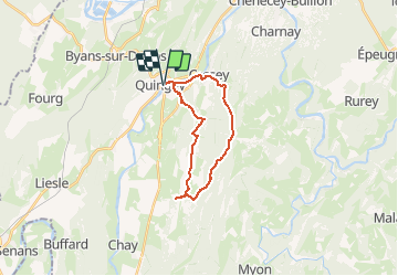
18.9 km

Max alt
545 m

Uphill gradient
475 m
Km-Effort
25 km

Min alt
260 m

Downhill gradient
475 m
Boucle
Yes
Creation date :
2020-01-21 08:00:33.279
Updated on :
2020-01-21 18:12:33.635

FREE GPS app for hiking
 SityTrail
IGN / Geographical institutes
SityTrail Plus
The world is yours!
About
Trail of 18.9 km to be discovered at Bourgogne-Franche-Comté, Doubs, Quingey. This trail is proposed by gerardmicheline.
Positioning
Country:
France
Region :
Bourgogne-Franche-Comté
Department/Province :
Doubs
Municipality :
Quingey
Location:
Unknown
Start:(Dec)
Start:(UTM)
718963 ; 5220675 (31T) N.
Comments