


spelonga

lygi
User
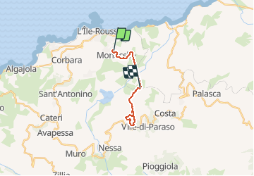

Length
15.2 km

Max alt
290 m

Uphill gradient
383 m
Km-Effort
20 km

Min alt
49 m

Downhill gradient
437 m
Boucle
No
Creation date :
2020-01-22 08:19:47.99
Updated on :
2020-01-22 11:32:28.952
3h11
Difficulty : Very easy

FREE GPS app for hiking
 SityTrail
IGN / Geographical institutes
SityTrail Plus
The world is yours!
About
Trail Nordic walking of 15.2 km to be discovered at Corsica, Haute-Corse, Monticello. This trail is proposed by lygi.
Description
rando
Positioning
Country:
France
Region :
Corsica
Department/Province :
Haute-Corse
Municipality :
Monticello
Location:
Unknown
Start:(Dec)
Start:(UTM)
496116 ; 4718665 (32T) N.
Comments