


SityTrail - champsaur 2020 ;depart prapic; lac de jujal

gerardmicheline
User
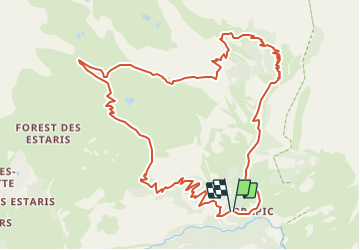

Length
13.6 km

Max alt
2287 m

Uphill gradient
929 m
Km-Effort
26 km

Min alt
1512 m

Downhill gradient
934 m
Boucle
Yes
Creation date :
2020-01-22 13:17:08.653
Updated on :
2020-01-22 13:17:08.653

FREE GPS app for hiking
 SityTrail
IGN / Geographical institutes
SityTrail Plus
The world is yours!
About
Trail of 13.6 km to be discovered at Provence-Alpes-Côte d'Azur, Hautes-Alpes, Orcières. This trail is proposed by gerardmicheline.
Positioning
Country:
France
Region :
Provence-Alpes-Côte d'Azur
Department/Province :
Hautes-Alpes
Municipality :
Orcières
Location:
Unknown
Start:(Dec)
Start:(UTM)
291289 ; 4952235 (32T) N.
Comments