


castel arnaud

ymobernard
User
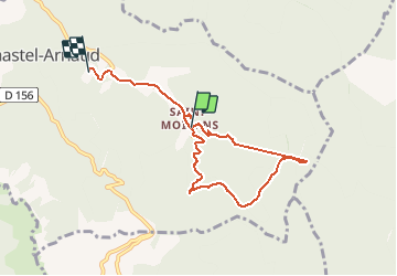

Length
7.1 km

Max alt
840 m

Uphill gradient
356 m
Km-Effort
11.8 km

Min alt
482 m

Downhill gradient
356 m
Boucle
No
Creation date :
2020-01-22 13:05:26.516
Updated on :
2020-01-22 15:38:09.161
1h26
Difficulty : Medium

FREE GPS app for hiking
 SityTrail
IGN / Geographical institutes
SityTrail Plus
The world is yours!
About
Trail Walking of 7.1 km to be discovered at Auvergne-Rhône-Alpes, Drôme, Chastel-Arnaud. This trail is proposed by ymobernard.
Positioning
Country:
France
Region :
Auvergne-Rhône-Alpes
Department/Province :
Drôme
Municipality :
Chastel-Arnaud
Location:
Unknown
Start:(Dec)
Start:(UTM)
676374 ; 4947239 (31T) N.
Comments