


Dordogne : Rocamadour/Le Vigan

mhetpierre
User
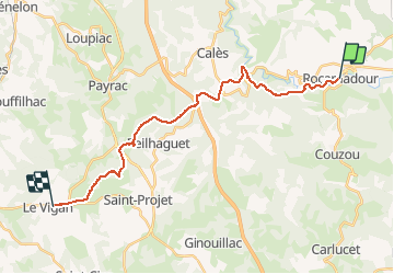

Length
22 km

Max alt
377 m

Uphill gradient
465 m
Km-Effort
29 km

Min alt
107 m

Downhill gradient
456 m
Boucle
No
Creation date :
2020-01-22 16:27:10.438
Updated on :
2020-01-22 16:28:38.05
--
Difficulty : Very easy

FREE GPS app for hiking
 SityTrail
IGN / Geographical institutes
SityTrail Plus
The world is yours!
About
Trail On foot of 22 km to be discovered at Occitania, Lot, Rocamadour. This trail is proposed by mhetpierre.
Positioning
Country:
France
Region :
Occitania
Department/Province :
Lot
Municipality :
Rocamadour
Location:
Unknown
Start:(Dec)
Start:(UTM)
390656 ; 4961553 (31T) N.
Comments