


cotignac

clintest
User
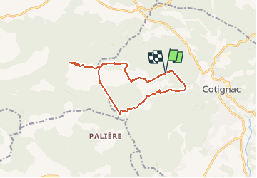

Length
13.9 km

Max alt
807 m

Uphill gradient
526 m
Km-Effort
21 km

Min alt
316 m

Downhill gradient
527 m
Boucle
Yes
Creation date :
2020-01-22 07:53:14.194
Updated on :
2020-01-23 14:56:02.499
4h20
Difficulty : Very easy

FREE GPS app for hiking
 SityTrail
IGN / Geographical institutes
SityTrail Plus
The world is yours!
About
Trail Walking of 13.9 km to be discovered at Provence-Alpes-Côte d'Azur, Var, Cotignac. This trail is proposed by clintest.
Positioning
Country:
France
Region :
Provence-Alpes-Côte d'Azur
Department/Province :
Var
Municipality :
Cotignac
Location:
Unknown
Start:(Dec)
Start:(UTM)
267579 ; 4824121 (32T) N.
Comments