


RS-Apprieu-Devez

raymondfn
User
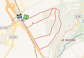

Length
5.6 km

Max alt
476 m

Uphill gradient
41 m
Km-Effort
6.2 km

Min alt
455 m

Downhill gradient
40 m
Boucle
Yes
Creation date :
2020-01-23 18:00:56.434
Updated on :
2020-02-06 14:58:03.209
1h08
Difficulty : Easy

FREE GPS app for hiking
 SityTrail
IGN / Geographical institutes
SityTrail Plus
The world is yours!
About
Trail Walking of 5.6 km to be discovered at Auvergne-Rhône-Alpes, Isère, Apprieu. This trail is proposed by raymondfn.
Positioning
Country:
France
Region :
Auvergne-Rhône-Alpes
Department/Province :
Isère
Municipality :
Apprieu
Location:
Unknown
Start:(Dec)
Start:(UTM)
693937 ; 5028484 (31T) N.
Comments