


Côte de l'Heute Mirebel

drarep
User
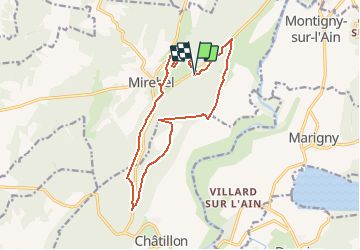

Length
14.9 km

Max alt
726 m

Uphill gradient
427 m
Km-Effort
21 km

Min alt
493 m

Downhill gradient
427 m
Boucle
Yes
Creation date :
2020-01-23 18:35:39.556
Updated on :
2020-01-23 18:37:14.142
4h20
Difficulty : Medium

FREE GPS app for hiking
 SityTrail
IGN / Geographical institutes
SityTrail Plus
The world is yours!
About
Trail Walking of 14.9 km to be discovered at Bourgogne-Franche-Comté, Jura, Hauteroche. This trail is proposed by drarep.
Description
Proposé par Jean Marc
Positioning
Country:
France
Region :
Bourgogne-Franche-Comté
Department/Province :
Jura
Municipality :
Hauteroche
Location:
Mirebel
Start:(Dec)
Start:(UTM)
709617 ; 5175297 (31T) N.
Comments