


gamay

XavierFaidix
User
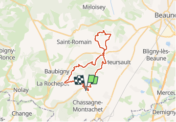

Length
26 km

Max alt
487 m

Uphill gradient
720 m
Km-Effort
36 km

Min alt
255 m

Downhill gradient
721 m
Boucle
Yes
Creation date :
2020-01-23 12:34:09.425
Updated on :
2020-01-24 06:36:47.937
2h50
Difficulty : Difficult

FREE GPS app for hiking
 SityTrail
IGN / Geographical institutes
SityTrail Plus
The world is yours!
About
Trail Mountain bike of 26 km to be discovered at Bourgogne-Franche-Comté, Côte-d'Or, Saint-Aubin. This trail is proposed by XavierFaidix.
Positioning
Country:
France
Region :
Bourgogne-Franche-Comté
Department/Province :
Côte-d'Or
Municipality :
Saint-Aubin
Location:
Unknown
Start:(Dec)
Start:(UTM)
631300 ; 5201160 (31T) N.
Comments