


2020-01-24 Chauvry

Bernardb44
User
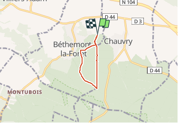

Length
3.4 km

Max alt
199 m

Uphill gradient
59 m
Km-Effort
4.1 km

Min alt
153 m

Downhill gradient
59 m
Boucle
Yes
Creation date :
2020-01-24 15:23:35.837
Updated on :
2020-01-24 16:15:59.007
52m
Difficulty : Very easy

FREE GPS app for hiking
 SityTrail
IGN / Geographical institutes
SityTrail Plus
The world is yours!
About
Trail Walking of 3.4 km to be discovered at Ile-de-France, Val-d'Oise, Béthemont-la-Forêt. This trail is proposed by Bernardb44.
Positioning
Country:
France
Region :
Ile-de-France
Department/Province :
Val-d'Oise
Municipality :
Béthemont-la-Forêt
Location:
Unknown
Start:(Dec)
Start:(UTM)
445916 ; 5433938 (31U) N.
Comments