


panorama-perche

olivieraron
User
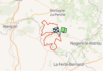

Length
97 km

Max alt
245 m

Uphill gradient
1277 m
Km-Effort
114 km

Min alt
75 m

Downhill gradient
1285 m
Boucle
Yes
Creation date :
2020-01-25 12:13:52.0
Updated on :
2020-01-25 12:21:01.626

FREE GPS app for hiking
 SityTrail
IGN / Geographical institutes
SityTrail Plus
The world is yours!
About
Trail of 97 km to be discovered at Normandy, Orne, Belforêt-en-Perche. This trail is proposed by olivieraron.
Positioning
Country:
France
Region :
Normandy
Department/Province :
Orne
Municipality :
Belforêt-en-Perche
Location:
Sérigny
Start:(Dec)
Start:(UTM)
320132 ; 5359801 (31U) N.
Comments