


RS-Rives-Champ du Loup

raymondfn
User
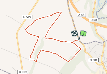

Length
5.3 km

Max alt
461 m

Uphill gradient
40 m
Km-Effort
5.8 km

Min alt
443 m

Downhill gradient
40 m
Boucle
Yes
Creation date :
2020-01-25 17:25:52.179
Updated on :
2021-02-21 17:30:41.791
1h33
Difficulty : Medium

FREE GPS app for hiking
 SityTrail
IGN / Geographical institutes
SityTrail Plus
The world is yours!
About
Trail Walking of 5.3 km to be discovered at Auvergne-Rhône-Alpes, Isère, Rives. This trail is proposed by raymondfn.
Positioning
Country:
France
Region :
Auvergne-Rhône-Alpes
Department/Province :
Isère
Municipality :
Rives
Location:
Unknown
Start:(Dec)
Start:(UTM)
694583 ; 5026867 (31T) N.
Comments