


cuvier appremont Yves

Yannick.Boireau
User
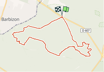

Length
11.3 km

Max alt
144 m

Uphill gradient
185 m
Km-Effort
13.8 km

Min alt
84 m

Downhill gradient
185 m
Boucle
Yes
Creation date :
2020-01-28 08:22:54.087
Updated on :
2020-01-28 11:51:52.814
3h13
Difficulty : Very easy

FREE GPS app for hiking
 SityTrail
IGN / Geographical institutes
SityTrail Plus
The world is yours!
About
Trail Walking of 11.3 km to be discovered at Ile-de-France, Seine-et-Marne, Fontainebleau. This trail is proposed by Yannick.Boireau.
Positioning
Country:
France
Region :
Ile-de-France
Department/Province :
Seine-et-Marne
Municipality :
Fontainebleau
Location:
Unknown
Start:(Dec)
Start:(UTM)
473174 ; 5365942 (31U) N.
Comments