


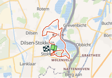
Rondje Stokkem...

bometdehamer
User

Length
15.8 km

Max alt
44 m

Uphill gradient
92 m
Km-Effort
17 km

Min alt
25 m

Downhill gradient
94 m
Boucle
Yes
Creation date :
2020-01-28 09:53:04.0
Updated on :
2020-01-28 15:06:48.125
4h47
Difficulty : Easy

FREE GPS app for hiking
 SityTrail
IGN / Geographical institutes
SityTrail Plus
The world is yours!
About
Trail Walking of 15.8 km to be discovered at Flanders, Limburg, Dilsen-Stokkem. This trail is proposed by bometdehamer.
Description
Langs Oude Maas, de Grensmaas, Koeweide, Deurlingsweert, Maasveld, Visakker, Schaapskuil, Veurzen, Stokkemerweerd, Negenoord, Kerkeweerd en afsluiten langs de Ouzeir. Mooie wandeling!
Photos


Positioning
Country:
Belgium
Region :
Flanders
Department/Province :
Limburg
Municipality :
Dilsen-Stokkem
Location:
Stokkem
Start:(Dec)
Start:(UTM)
692517 ; 5655661 (31U) N.
Comments