


z la lieutenante 28-01-20

cb8310
User
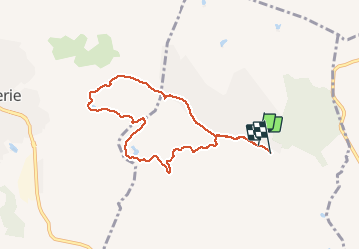

Length
7.7 km

Max alt
97 m

Uphill gradient
95 m
Km-Effort
8.9 km

Min alt
52 m

Downhill gradient
97 m
Boucle
No
Creation date :
2020-01-28 13:00:56.279
Updated on :
2020-01-30 04:53:07.988
2h36
Difficulty : Very easy

FREE GPS app for hiking
 SityTrail
IGN / Geographical institutes
SityTrail Plus
The world is yours!
About
Trail Walking of 7.7 km to be discovered at Provence-Alpes-Côte d'Azur, Var, Puget-sur-Argens. This trail is proposed by cb8310.
Description
rando sans difficultés
Photos


Positioning
Country:
France
Region :
Provence-Alpes-Côte d'Azur
Department/Province :
Var
Municipality :
Puget-sur-Argens
Location:
Unknown
Start:(Dec)
Start:(UTM)
313407 ; 4818319 (32T) N.
Comments