


Le Suel Le Chambon

pb07
User
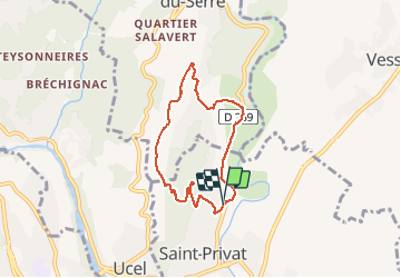

Length
6.4 km

Max alt
371 m

Uphill gradient
183 m
Km-Effort
8.9 km

Min alt
236 m

Downhill gradient
184 m
Boucle
Yes
Creation date :
2020-01-28 14:37:25.562
Updated on :
2020-01-28 16:33:20.732
1h35
Difficulty : Very easy

FREE GPS app for hiking
 SityTrail
IGN / Geographical institutes
SityTrail Plus
The world is yours!
About
Trail Walking of 6.4 km to be discovered at Auvergne-Rhône-Alpes, Ardèche, Saint-Privat. This trail is proposed by pb07.
Positioning
Country:
France
Region :
Auvergne-Rhône-Alpes
Department/Province :
Ardèche
Municipality :
Saint-Privat
Location:
Unknown
Start:(Dec)
Start:(UTM)
612117 ; 4943341 (31T) N.
Comments