


Bron Parilly 27 01 20 -6.6 a 72 g 0.5 d6

jtraverse
User
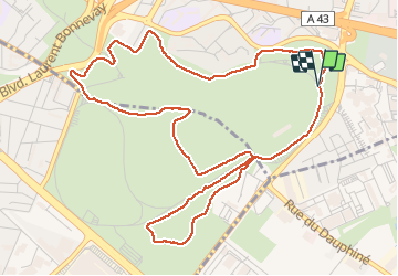

Length
6.6 km

Max alt
217 m

Uphill gradient
72 m
Km-Effort
7.6 km

Min alt
183 m

Downhill gradient
77 m
Boucle
Yes
Creation date :
2020-01-28 12:52:01.065
Updated on :
2020-01-29 08:41:22.488
4h32
Difficulty : Very easy

FREE GPS app for hiking
 SityTrail
IGN / Geographical institutes
SityTrail Plus
The world is yours!
About
Trail Walking of 6.6 km to be discovered at Auvergne-Rhône-Alpes, Métropole de Lyon, Bron. This trail is proposed by jtraverse.
Description
BRON - PARILLY Trajet voiture 6.0 km, 12 min
GPS Pk : 45.7226, 4.9135 ou 45°43'21.4"N 4°54'48.6"E
Adresse : Boulevard des Turfistes 69500 BRON
Positioning
Country:
France
Region :
Auvergne-Rhône-Alpes
Department/Province :
Métropole de Lyon
Municipality :
Bron
Location:
Unknown
Start:(Dec)
Start:(UTM)
648887 ; 5065069 (31T) N.
Comments