


Flayosc

aljac
User
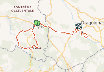

Length
17.3 km

Max alt
339 m

Uphill gradient
252 m
Km-Effort
21 km

Min alt
169 m

Downhill gradient
391 m
Boucle
No
Creation date :
2020-01-28 12:58:58.308
Updated on :
2020-01-28 21:42:56.78
2h34
Difficulty : Very easy

FREE GPS app for hiking
 SityTrail
IGN / Geographical institutes
SityTrail Plus
The world is yours!
About
Trail Walking of 17.3 km to be discovered at Provence-Alpes-Côte d'Azur, Var, Flayosc. This trail is proposed by aljac.
Positioning
Country:
France
Region :
Provence-Alpes-Côte d'Azur
Department/Province :
Var
Municipality :
Flayosc
Location:
Unknown
Start:(Dec)
Start:(UTM)
289190 ; 4823130 (32T) N.
Comments