


2901

maxEA65
User

Length
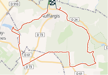
11.8 km

Max alt
187 m

Uphill gradient
121 m
Km-Effort
13.4 km

Min alt
137 m

Downhill gradient
128 m
Boucle
No
Creation date :
2020-01-29 12:20:11.455
Updated on :
2020-01-29 15:32:28.901
2h07
Difficulty : Very easy

FREE GPS app for hiking
 SityTrail
IGN / Geographical institutes
SityTrail Plus
The world is yours!
About
Trail Walking of 11.8 km to be discovered at Ile-de-France, Yvelines, Auffargis. This trail is proposed by maxEA65.
Positioning
Country:
France
Region :
Ile-de-France
Department/Province :
Yvelines
Municipality :
Auffargis
Location:
Unknown
Start:(Dec)
Start:(UTM)
417918 ; 5394974 (31U) N.
Comments