Domitius

Rudy07
User

Length
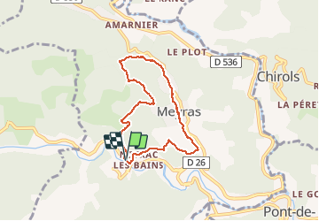
6.6 km

Max alt
521 m

Uphill gradient
216 m
Km-Effort
9.5 km

Min alt
340 m

Downhill gradient
212 m
Boucle
Yes
Creation date :
2020-01-29 12:46:36.506
Updated on :
2020-01-29 18:53:20.253
1h48
Difficulty : Easy

FREE GPS app for hiking
 SityTrail
IGN / Geographical institutes
SityTrail Plus
The world is yours!
About
Trail Walking of 6.6 km to be discovered at Auvergne-Rhône-Alpes, Ardèche, Meyras. This trail is proposed by Rudy07.
Positioning
Country:
France
Region :
Auvergne-Rhône-Alpes
Department/Province :
Ardèche
Municipality :
Meyras
Location:
Unknown
Start:(Dec)
Start:(UTM)
599698 ; 4947445 (31T) N.
Comments