


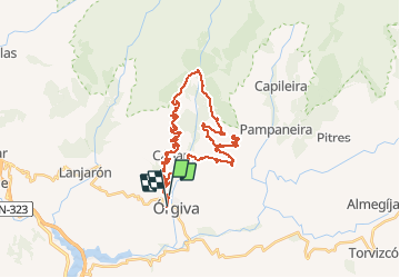
Orgiva Canar O'Celin

jpipacific
User


1h29
Difficulty : Medium

FREE GPS app for hiking
 SityTrail
IGN / Geographical institutes
SityTrail Plus
The world is yours!
About
Trail Moto cross of 43 km to be discovered at Andalusia, Granada, Órgiva. This trail is proposed by jpipacific.
Description
Randonnée faite le 29 janvier 2020
En duo avec Honda Africa Twin CRF 1000 DCT
Très jolie rando assez facile même en duo.
Un peu délicat lors des passages enneigés mais pas trop difficile.
Visite au centre Bouddhiste O'Celin
Photos


Positioning
Comments