


191109 malte cicerone 18

usben
User
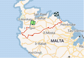

Length
24 km

Max alt
238 m

Uphill gradient
441 m
Km-Effort
30 km

Min alt
5 m

Downhill gradient
535 m
Boucle
No
Creation date :
2019-11-09 08:14:04.099
Updated on :
2020-01-29 20:38:52.284
6h27
Difficulty : Very easy

FREE GPS app for hiking
 SityTrail
IGN / Geographical institutes
SityTrail Plus
The world is yours!
About
Trail Walking of 24 km to be discovered at Northern Region, Unknown, L-Imġarr. This trail is proposed by usben.
Positioning
Country:
Malta
Region :
Northern Region
Department/Province :
Unknown
Municipality :
L-Imġarr
Location:
Unknown
Start:(Dec)
Start:(UTM)
442837 ; 3975204 (33S) N.
Comments