Trail Running Courrières - terrils - fouquieres les lens - Photo

terrils - fouquieres les lens

© OpenStreetMap contributors
Length
Length
15.9 km
Max alt
Max alt
64 m
Uphill gradient
Uphill gradient
208 m
Km-Effort
Km-Effort  
18.7 km
Min alt
Min alt
15 m
Downhill gradient
Downhill gradient
209 m
Boucle
Boucle
Yes
Creation date :
2014-12-10 00:00:00.0
Updated on :
2014-12-10 00:00:00.0

(0 Reviews)

Running
Running
2h09
Difficulty : Easy

Scan this QR Code to open this trail in the SityTrail application

FREE GPS app for hiking

Logo SityTrail SityTrail

IGN / Geographical institutes

Download SityTrail from the App Store Download SityTrail from Google Play

Logo SityTrail SityTrail World

The world is yours!

Download SityTrail from the App Store Download SityTrail from Google Play Download SityTrail on Huawei AppGallery

About

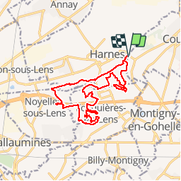
Trail Running of 15.9 km to be discovered at Hauts-de-France, Pas-de-Calais, Courrières. This trail is proposed by jamboxland.

Description

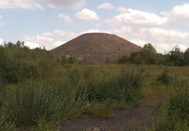
belle sortie automnale à  ne pas faire en famille. Trop sportif : monotrace   ronces et montées/descente de terrils pas très stables.

Elevation profile

Photos

Points of interest

Point of interest Fouquières-lès-Lens - Point 2 - Photo
jamboxland
FOUQUIÈRES-LÈS-LENS 

Positioning

Country:
France
Region :
Hauts-de-France
Department/Province :
Pas-de-Calais
Municipality :
Courrières
Location:
Unknown
Start:(UTM)
494128 ; 5588272 (31U) N.

Trails nearby

Trail Walking Méricourt - MERICOURT DECOUVERTE 1er partie - Photo
Walking
PRO

Walking

Very easy
Méricourt, Hauts-de-France, Pas-de-Calais, France
8.1 km | 8.7 km-effort
1h 57min
Yes
Trail Walking Hénin-Beaumont - Parc des Iles Hennin Drocourt - Photo
Walking
avdem

Walking

Easy
Hénin-Beaumont, Hauts-de-France, Pas-de-Calais, France
3.5 km | 4.7 km-effort
1h 4min
Yes
Trail On foot Oignies - oignies et le parc des hautois - Photo
On foot
Templeuveenmarche

On foot

Medium
(1)
Oignies, Hauts-de-France, Pas-de-Calais, France
9.8 km | 11.1 km-effort
Unknown
Yes
Trail Walking Méricourt - MERICOURT DECOUVERTE 1er partie - Photo
Walking
abalcerek

Walking

Very easy
Méricourt, Hauts-de-France, Pas-de-Calais, France
8.1 km | 8.7 km-effort
2h 41min
Yes
Trail Walking Méricourt - Mericourt découverte - Photo
Walking
abalcerek

Walking

Very easy
Méricourt, Hauts-de-France, Pas-de-Calais, France
11.1 km | 12 km-effort
2h 26min
No
Trail Walking Oignies - Oignies  - Photo
Walking
roclem421

Walking

Difficult
Oignies, Hauts-de-France, Pas-de-Calais, France
11.2 km | 12.8 km-effort
2h 34min
Yes
Trail Walking Méricourt - MERICOURT DECOUVERTE 2e partie - Photo
Walking
PRO

Walking

Easy
Méricourt, Hauts-de-France, Pas-de-Calais, France
6.1 km | 6.5 km-effort
3h 0min
Yes
Trail Mountain bike Annay - Rando de la St Valentin, Annay sous Lens - Photo
Mountain bike
tracegps

Mountain bike

Medium
Annay, Hauts-de-France, Pas-de-Calais, France
34 km | 37 km-effort
2h 15min
Yes
Trail Walking Oignies - Oignies  - Photo
Walking
roclem421

Walking

Medium
Oignies, Hauts-de-France, Pas-de-Calais, France
10.8 km | 12.2 km-effort
2h 30min
Yes


Close
My subscriptions