


ONNION-L'ALPAGE

JCLUTT
User
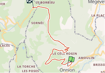

Length
7.3 km

Max alt
1256 m

Uphill gradient
469 m
Km-Effort
12.1 km

Min alt
807 m

Downhill gradient
34 m
Boucle
No
Creation date :
2020-01-30 08:56:10.176
Updated on :
2020-01-30 09:05:25.097
15m
Difficulty : Very easy

FREE GPS app for hiking
 SityTrail
IGN / Geographical institutes
SityTrail Plus
The world is yours!
About
Trail Car of 7.3 km to be discovered at Auvergne-Rhône-Alpes, Upper Savoy, Onnion. This trail is proposed by JCLUTT.
Description
Restaurant l'Alpage 4963 route de Plaine Joux 74250 Bogève

Positioning
Country:
France
Region :
Auvergne-Rhône-Alpes
Department/Province :
Upper Savoy
Municipality :
Onnion
Location:
Unknown
Start:(Dec)
Start:(UTM)
305478 ; 5116425 (32T) N.
Comments