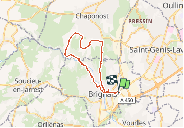
Trail On foot Brignais - brignais le garon - Photo
 maclobar
maclobar

User

© OpenStreetMap contributors
Length
Length
12.6 km
Max alt
Max alt
324 m
Uphill gradient
Uphill gradient
180 m
Km-Effort
Km-Effort  
15 km
Min alt
Min alt
205 m
Downhill gradient
Downhill gradient
175 m
Boucle
Boucle
Yes
Creation date :
2020-01-30 08:22:06.53
Updated on :
2020-01-31 09:21:56.414

(0 Reviews)

On foot
On foot
--
Difficulty : Very easy
Walking
Walking
3h57
Difficulty : Very easy

Scan this QR Code to open this trail in the SityTrail application

FREE GPS app for hiking

Logo SityTrail SityTrail

IGN / Geographical institutes

Download SityTrail from the App Store Download SityTrail from Google Play

Logo SityTrail SityTrail Plus

The world is yours!

Download SityTrail from the App Store Download SityTrail from Google Play Download SityTrail on Huawei AppGallery

About

Trail On foot of 12.6 km to be discovered at Auvergne-Rhône-Alpes, Rhône, Brignais. This trail is proposed by maclobar.

Description

Belle randonnée au bord du Garon, petite rivière.  Attention à ne pas longer le Garon à gauche avant le premier pont s'il y a des crues. Traverser alors le pont et prendre au fond à gauche la route parallèle qui conduit comme prévu aux acqueducs. Par beau temps pause possible à la plage naturelle.

Elevation profile

Positioning

Country:
France
Region :
Auvergne-Rhône-Alpes
Department/Province :
Rhône
Municipality :
Brignais
Location:
Unknown
Start:(UTM)
637396 ; 5059307 (31T) N.

Comments

Please log in to post a review or rate the element


ballade le long de la rivière. puis les champs et la Dame Blanche: équitation.


Close
My subscriptions