


31.01.2020 - CINTRE & LA CHAPELLE THOUARAULT.Réel corrigé

babeth35
User
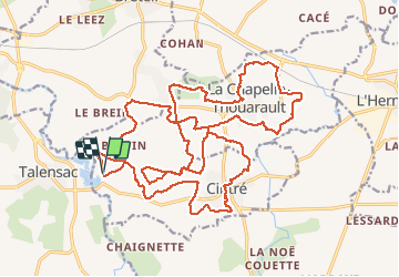

Length
29 km

Max alt
65 m

Uphill gradient
209 m
Km-Effort
32 km

Min alt
26 m

Downhill gradient
209 m
Boucle
Yes
Creation date :
2020-01-31 07:19:28.0
Updated on :
2020-02-02 13:57:23.939
8h18
Difficulty : Difficult

FREE GPS app for hiking
 SityTrail
IGN / Geographical institutes
SityTrail Plus
The world is yours!
About
Trail Walking of 29 km to be discovered at Brittany, Ille-et-Vilaine, Cintré. This trail is proposed by babeth35.
Positioning
Country:
France
Region :
Brittany
Department/Province :
Ille-et-Vilaine
Municipality :
Cintré
Location:
Unknown
Start:(Dec)
Start:(UTM)
581170 ; 5329008 (30U) N.
Comments