


charmansom

oliviergau
User
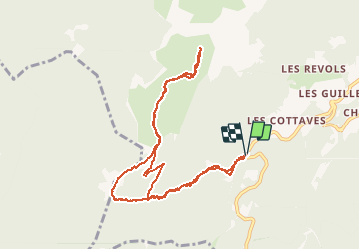

Length
10.4 km

Max alt
1835 m

Uphill gradient
789 m
Km-Effort
21 km

Min alt
1123 m

Downhill gradient
790 m
Boucle
Yes
Creation date :
2020-02-01 06:32:03.014
Updated on :
2020-02-01 09:36:19.567
3h00
Difficulty : Very easy

FREE GPS app for hiking
 SityTrail
IGN / Geographical institutes
SityTrail Plus
The world is yours!
About
Trail Touring skiing of 10.4 km to be discovered at Auvergne-Rhône-Alpes, Isère, Saint-Pierre-de-Chartreuse. This trail is proposed by oliviergau.
Positioning
Country:
France
Region :
Auvergne-Rhône-Alpes
Department/Province :
Isère
Municipality :
Saint-Pierre-de-Chartreuse
Location:
Unknown
Start:(Dec)
Start:(UTM)
717118 ; 5021125 (31T) N.
Comments