


Course à pied, L''areuse

asc
User
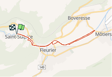

Length
8.2 km

Max alt
764 m

Uphill gradient
53 m
Km-Effort
8.9 km

Min alt
732 m

Downhill gradient
54 m
Boucle
Yes
Creation date :
2014-12-11 00:00:00.0
Updated on :
2014-12-11 00:00:00.0
--
Difficulty : Unknown

FREE GPS app for hiking
 SityTrail
IGN / Geographical institutes
SityTrail Plus
The world is yours!
About
Trail Other activity of 8.2 km to be discovered at Neuchâtel, Unknown, Val-de-Travers. This trail is proposed by asc.
Description
Ascension de la Ruinette par le col de la Lire, depuis le bas du barrage de Mauvoisin
Positioning
Country:
Switzerland
Region :
Neuchâtel
Department/Province :
Unknown
Municipality :
Val-de-Travers
Location:
Unknown
Start:(Dec)
Start:(UTM)
314416 ; 5198088 (32T) N.
Comments