


clapiers St Mathieu le Mas neuf aller-retour

ARVIEU
User

Length
61 km

Max alt
352 m

Uphill gradient
904 m
Km-Effort
73 km

Min alt
61 m

Downhill gradient
905 m
Boucle
Yes
Creation date :
2014-12-10 00:00:00.0
Updated on :
2014-12-10 00:00:00.0
4h42
Difficulty : Medium

FREE GPS app for hiking
 SityTrail
IGN / Geographical institutes
SityTrail Plus
The world is yours!
About
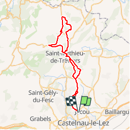
Trail Mountain bike of 61 km to be discovered at Occitania, Hérault, Clapiers. This trail is proposed by ARVIEU.
Description
clapiers st mathieu valflaunes lauret le mas neuf st mathieu clapiers
Positioning
Country:
France
Region :
Occitania
Department/Province :
Hérault
Municipality :
Clapiers
Location:
Unknown
Start:(Dec)
Start:(UTM)
572635 ; 4834476 (31T) N.
Comments