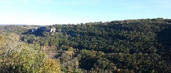
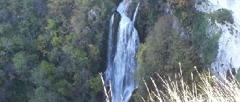
Trail Walking Autoire - Le cirque d'Autoire - Photo

Le cirque d'Autoire

 sdroneau
sdroneau

User

© OpenStreetMap contributors
Length
Length
16 km
Max alt
Max alt
418 m
Uphill gradient
Uphill gradient
457 m
Km-Effort
Km-Effort  
22 km
Min alt
Min alt
168 m
Downhill gradient
Downhill gradient
455 m
Boucle
Boucle
Yes
Creation date :
2014-12-10 00:00:00.0
Updated on :
2014-12-10 00:00:00.0

(0 Reviews)

Walking
Walking
3h40
Difficulty : Medium

Scan this QR Code to open this trail in the SityTrail application

FREE GPS app for hiking

Logo SityTrail SityTrail

IGN / Geographical institutes

Download SityTrail from the App Store Download SityTrail from Google Play

Logo SityTrail SityTrail Plus

The world is yours!

Download SityTrail from the App Store Download SityTrail from Google Play Download SityTrail on Huawei AppGallery

About

Trail Walking of 16 km to be discovered at Occitania, Lot, Autoire. This trail is proposed by sdroneau.

Description

Au départ du parking situé à l'entrée du village d'Autoire, prenez la direction du château des Anglais (montée assez difficile). L'accès aux ruines du château est hors circuit (environ 400m aller/retour). Une fois sur le plateau, profitez d'une vue magnifique sur le cirque et sa cascade. Direction le Gouffre de Padirac puis Loubressac par des chemins très praticables avec peu de dénivelé. Puis c'est la descente vers Autoire...

Elevation profile

Photos

Points of interest

Point of interest Autoire - Autoire - Photo
sdroneau
AUTOIRE 
Point of interest Autoire - Cirque d'Autoire - Photo
sdroneau
Point of interest Loubressac - Cascade - Photo
sdroneau
LOUBRESSAC 
Point of interest Loubressac - Château de Castelnau - Photo
sdroneau

Positioning

Country:
France
Region :
Occitania
Department/Province :
Lot
Municipality :
Autoire
Location:
Unknown
Start:(UTM)
406900 ; 4967577 (31T) N.


Close
My subscriptions