Mirmande

bob2023
User
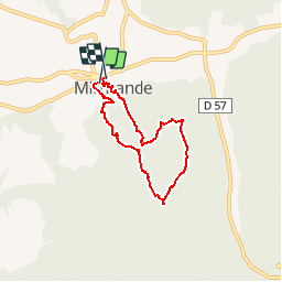

Length
5.7 km

Max alt
420 m

Uphill gradient
246 m
Km-Effort
9 km

Min alt
175 m

Downhill gradient
244 m
Boucle
Yes
Creation date :
2018-08-26 08:32:33.079
Updated on :
2018-08-26 08:32:33.09
2h05
Difficulty : Medium

FREE GPS app for hiking
 SityTrail
IGN / Geographical institutes
SityTrail Plus
The world is yours!
About
Trail Walking of 5.7 km to be discovered at Auvergne-Rhône-Alpes, Drôme, Mirmande. This trail is proposed by bob2023.
Description
Sympathique balade. Dénivelé moyen. Beau point de vue sur la vallée du Rhône, avec arrivée dans le très joli village de Mirmande. Une belle randonnée d'après-midi.

Positioning
Country:
France
Region :
Auvergne-Rhône-Alpes
Department/Province :
Drôme
Municipality :
Mirmande
Location:
Unknown
Start:(Dec)
Start:(UTM)
645300 ; 4951138 (31T) N.
Comments