


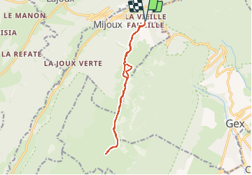
2020-02-03_10h33m45_col de la faucille mont rond colomby- de- gex 12 km 600 m

gerardmicheline
User

Length
12.3 km

Max alt
1681 m

Uphill gradient
583 m
Km-Effort
20 km

Min alt
1317 m

Downhill gradient
585 m
Boucle
Yes
Creation date :
2020-02-03 09:33:45.97
Updated on :
2020-02-03 09:33:48.045

FREE GPS app for hiking
 SityTrail
IGN / Geographical institutes
SityTrail Plus
The world is yours!
About
Trail of 12.3 km to be discovered at Auvergne-Rhône-Alpes, Ain, Mijoux. This trail is proposed by gerardmicheline.
Positioning
Country:
France
Region :
Auvergne-Rhône-Alpes
Department/Province :
Ain
Municipality :
Mijoux
Location:
Unknown
Start:(Dec)
Start:(UTM)
270399 ; 5139191 (32T) N.
Comments