


Murol

bubuserge
User
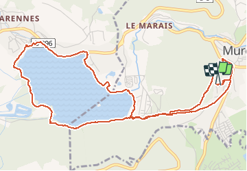

Length
6.8 km

Max alt
918 m

Uphill gradient
164 m
Km-Effort
9 km

Min alt
848 m

Downhill gradient
173 m
Boucle
Yes
Creation date :
2020-02-03 08:27:44.0
Updated on :
2020-02-03 10:19:53.629
1h38
Difficulty : Unknown

FREE GPS app for hiking
 SityTrail
IGN / Geographical institutes
SityTrail Plus
The world is yours!
About
Trail Walking of 6.8 km to be discovered at Auvergne-Rhône-Alpes, Puy-de-Dôme, Murol. This trail is proposed by bubuserge.
Positioning
Country:
France
Region :
Auvergne-Rhône-Alpes
Department/Province :
Puy-de-Dôme
Municipality :
Murol
Location:
Unknown
Start:(Dec)
Start:(UTM)
495295 ; 5046374 (31T) N.
Comments