


cerceron

ninia
User
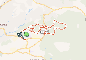

Length
10.7 km

Max alt
118 m

Uphill gradient
217 m
Km-Effort
13.6 km

Min alt
35 m

Downhill gradient
216 m
Boucle
Yes
Creation date :
2020-02-03 08:01:59.99
Updated on :
2020-02-03 10:59:57.173
2h55
Difficulty : Very easy

FREE GPS app for hiking
 SityTrail
IGN / Geographical institutes
SityTrail Plus
The world is yours!
About
Trail Walking of 10.7 km to be discovered at Provence-Alpes-Côte d'Azur, Var, Saint-Raphaël. This trail is proposed by ninia.
Positioning
Country:
France
Region :
Provence-Alpes-Côte d'Azur
Department/Province :
Var
Municipality :
Saint-Raphaël
Location:
Unknown
Start:(Dec)
Start:(UTM)
321697 ; 4811435 (32T) N.
Comments