


Châtillon sur Azerues

Galoche
User
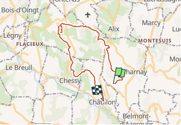

Length
14 km

Max alt
359 m

Uphill gradient
237 m
Km-Effort
17.4 km

Min alt
218 m

Downhill gradient
311 m
Boucle
No
Creation date :
2020-02-03 08:36:16.0
Updated on :
2020-02-03 14:02:57.457
4h43
Difficulty : Medium

FREE GPS app for hiking
 SityTrail
IGN / Geographical institutes
SityTrail Plus
The world is yours!
About
Trail Walking of 14 km to be discovered at Auvergne-Rhône-Alpes, Rhône, Charnay. This trail is proposed by Galoche.
Description
Rando sympathique
Positioning
Country:
France
Region :
Auvergne-Rhône-Alpes
Department/Province :
Rhône
Municipality :
Charnay
Location:
Unknown
Start:(Dec)
Start:(UTM)
628255 ; 5082674 (31T) N.
Comments