


Lac de Guery

bubuserge
User
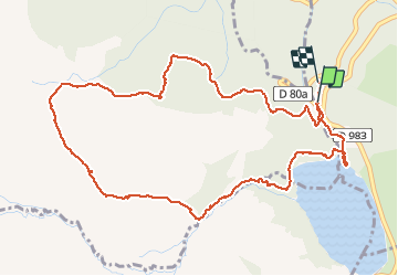

Length
6.2 km

Max alt
1357 m

Uphill gradient
135 m
Km-Effort
8 km

Min alt
1246 m

Downhill gradient
143 m
Boucle
Yes
Creation date :
2020-02-03 13:20:00.0
Updated on :
2020-02-03 16:10:52.001
1h44
Difficulty : Unknown

FREE GPS app for hiking
 SityTrail
IGN / Geographical institutes
SityTrail Plus
The world is yours!
About
Trail Walking of 6.2 km to be discovered at Auvergne-Rhône-Alpes, Puy-de-Dôme, Orcival. This trail is proposed by bubuserge.
Positioning
Country:
France
Region :
Auvergne-Rhône-Alpes
Department/Province :
Puy-de-Dôme
Municipality :
Orcival
Location:
Unknown
Start:(Dec)
Start:(UTM)
485984 ; 5052003 (31T) N.
Comments