


Les grottes de Châteauneuf

bubuserge
User

Length
6.7 km

Max alt
950 m

Uphill gradient
243 m
Km-Effort
10 km

Min alt
728 m

Downhill gradient
243 m
Boucle
Yes
Creation date :
2020-02-04 08:19:12.0
Updated on :
2020-02-04 10:37:10.728
1h46
Difficulty : Unknown

FREE GPS app for hiking
 SityTrail
IGN / Geographical institutes
SityTrail Plus
The world is yours!
About
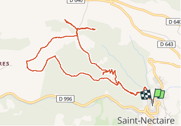
Trail Walking of 6.7 km to be discovered at Auvergne-Rhône-Alpes, Puy-de-Dôme, Saint-Nectaire. This trail is proposed by bubuserge.
Positioning
Country:
France
Region :
Auvergne-Rhône-Alpes
Department/Province :
Puy-de-Dôme
Municipality :
Saint-Nectaire
Location:
Unknown
Start:(Dec)
Start:(UTM)
499410 ; 5048345 (31T) N.
Comments